Issue 5: Ocean-going vessels could not have reached the proposed Great Lakes Book of Mormon areas via the St. Lawrence River
In search of four seas: sea north, sea south, sea east, sea west
Advocates of Great-Lakes-area Book of Mormon geography have long been enamored by a single Book of Mormon verse: Helaman 3:8. That verse summarizes a major Nephite geographic expansion that took place about 40 B.C. when many Nephites migrated northward. The Helaman verse’s exact words:
“It came to pass that they did multiply and spread, and did go forth from the land southward to the land northward, and did spread insomuch that they began to cover the face of the whole earth, from the sea south to the sea north, from the sea west to the sea east.”
Stretching definitions—regarding assumptions as facts
Their eyes eventually focused on the Great Lakes, which today separate Canada from the United States of America. By stretching the accepted definition the term of “seas” to include the term “lakes,” they sought to justify their own unsupportable that the Great Lakes area is the terrain referred to in Helaman 3:8.
An even greater stretch—all three ocean-crossing civilizations (Jaredites, Lehi’s family, and Mulekites) arriving more than a thousand miles inland.
After accepting their assumed Great Lakes redefinitions as “facts,” they then attempted to explain how the three different groups crossed an ocean during three different centuries—and each arrived near the east-west middle of the North American continent, more than a thousand miles inland.
Only the portion of the voyage pertaining to travel via the St. Lawrence River will be considered in this setting. A number of pertinent facts need to be presented.
Sailing via the St. Lawrence River?
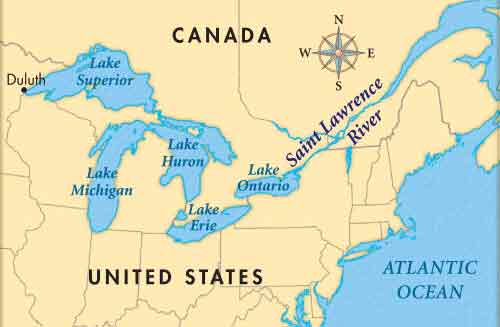
Looking at a map, the tempting conclusion was that their arrivals came via the St. Lawrence River, which stretched from the juncture of the St. Lawrence Bay with the Atlantic Ocean, all the way to Lake Ontario, the closest of the five Great Lakes.
A typical example of that assumption is found in Phyllis Carol Olive’s book: The Lost Sheep of Ancient America: Bringing the Lands and People of the Book of Mormon to Life (Cedar Fort, Inc., Springville, Utah, 2015.) She proposed travel mileage of the Jaredies as being
- from Rabit (just off the coast of western Africa to the Verdes Isles (1,664 miles);
- then across the Atlantic to Cuba (3,562 miles);
- then up the Atlantic coast to the St. Larence River (1,739 miles),
- and down to Lake Ontario (710 miles). (p. 20)
Some significant facts concerning travel on the St. Lawrence River and in the Great Lakes
Fact Number One: Moving Against the Flow
Vessels traveling on the St. Lawrence River from the Atlantic Ocean westward to Lake Ontario are not sailing down the river, they are traveling up the river. The river flows from the Great Lakes out to the Atlantic. Sailing for hundreds of miles against the current would make the voyage extremely difficult, if not impossible, for any of the three Book of Mormon migrations.
Fact Number Two: Sailing Uphill
Not only are westward-sailing vessels laboring against the current up the river, they also are climbing in altitude! At the east end of Lake Ontario, the river level is 242 feet above the Atlantic Sea level. Today, ships are lifted or lowered in seven locks along the river.
Fact Number Three: Length of the River
The official length of the St. Lawrence River is 743.8 miles, as shown on present-day publications and descriptions.
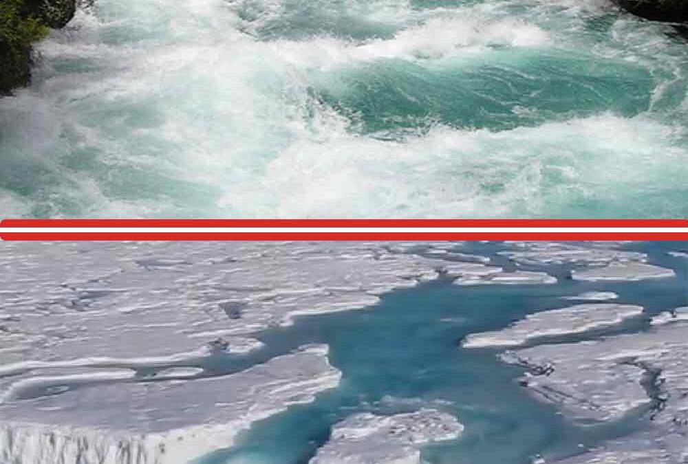
Fact Number Four: The Lachine Rapids, since the beginning, has made further upriver travel by ships impassible.
Description: The Lachine Rapids are a series of rapids on the Saint Lawrence River, between the Island of Montreal and the South Shore. The rapids are more than three miles in length. They contain large standing waves because the water volume and current do not change because of the shelf-like drops. Until the recent installations of locks detouring around the rapids, the river was absolutely impassable by ships and boats, small and large.
Fact Number Five: Portions of the river freeze in winter, even in modern times.
Marine shipping activities and navigation on the St. Lawrence are seriously influenced by seasonal changes and weather conditions. In the winter, precipitation and the presence of ice in the shipping lanes downstream from Montreal add a major degree of complexity to navigating the river. Many of the Great Lakes also have a fair bit of freezing to them, including Lake Erie which freezes over almost every year.
Conclusion: There is no way the Jaredites, Lehi’s Family, or the Mulekites, could have reached the Great Lakes area by sailing up the St. Lawrence River!
*****
Issue 6: The New York Hill Cumorah’s Location Does Not Conform to the Book of Mormon’s Description of Related Lands, Cities and Bodies of Water
It lacks geographic conformity. For example:
- It is not near the Land and City of Desolation (Land: Mormon 3:5; 4:2, 19; 6:2, 4, 6; Alma 22:30-32; 50:34) (City: Mormon 3:7; 4:2, 3, 8, 13, 19) (Hill: 6:2, 4, 6; 11; 8:2).
- It is not near the narrow pass (“narrow pass which led to the land southward”) (Mormon 3:5).
- It is not situated in a cleared “land” large enough that tens of thousands of people could camp on it and sustain themselves there for several years. (Mormon 6:2-6)
- Is not near the Hill Shim, in the land Antum. (Mormon 1:2-3; 4:23).
- It is not near the seashore—a key passage Ether 9:3: “the Lord warned Omer in a dream that he should depart out of the land; wherefore Omer departed out of the land with his family, and traveled many days, and came over and passed by the hill of Shim, and came over by the place where the Nephites were destroyed [Cumorah], and from thence eastward, and came to a place which was called Ablom, by the seashore, and there he pitched his tent, and also his sons and his daughters.”
- It is not near the very large waters of Ripliancum. (Ether 15:8, 11).
- It is not in a temporate climate where sufficient multiple crops can be harvested to feed all the people camped nearby.
- It is not a significant landmark. Thousands of Nephites, gathering from hundreds of miles away, needed to see it from a distance and recognize it. Many people must have known its location and were able to answer gathering Nephites’ questions about it and about its exact location.
- It is not a free-standing hill so people can camp around it.
- It does not provide a military advantage if a major battle is fought on and around it.